Printable Map
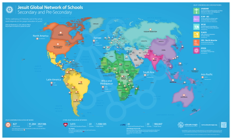
Jesuit Global Network of Schools and Universities


Click on each color to see how it relates to the holistic vision of Jesuit Education
The Global Maps on this page encompass the world of Education from the six Jesuit Conferences- from kindergarten schools to universities and include the Schools and Educational Projects of the two other important Jesuit education networks of Fe y Alegría and the Jesuit Refugee Service (JRS).
The two types of Maps found on this page the “Jesuit Universities and Schools Map” and the “Secondary and Pre-secondary Schools Maps ” show the richness and diversity of the global network.
The Combined Map includes the Jesuit and Ignatian higher education institutions and the secondary and presecondary education schools that belong to the regional Jesuit Conference Education Networks. For a list of University Networks and Institutions please click here. For a list of Jesuit Schools check out the Large Printable Map (below) or the School Profiles page here.
These maps are based on the Winkel Tripel projection. They have been designed with a “vector technology” (PDF and EPS) so that they can be printed in high quality in virtually any size to best suit your purpose.
©Copyright Society of Jesus, Secretariat for Education, General Curia, Roma. Designed by Educate Magis.

In the tabs below the Combined Jesuit Universities and Schools Map and Jesuit Secondary and Pre-secondary School Maps are available in ISO Standard (“A” Series), US Paper Size, and Digital (16:9) formats. The maps are downloadable in different file types to be either printed or included in a presentation or website. Please click the “hand” thumbnail on the map to see the downloadable files.
1. Small Map
The Small Map shows the Schools and Educational Projects in the six Jesuit Regions of the world and contains a basic legend. This small map is designed to be used in presentations or be printed in large or small sheet of paper and might for example be used in classrooms or for parent meetings. It is available in PDF, EPS, PNG and JPG file types.
- ISO Standard “A” Series print format – is used internationally
- US Paper Size format – is used mostly in North America and Latin America
- The digital 16:9 format is suitable for HD screens
Please click the “hand” thumbnail above to see the downloadable files.
Last Published on 21st September 2022.

2. Large Map
The Large Map shows the Schools in the six Jesuit Regions of the world and contains a more detailed legend with: School Name, City, Country, Region. It also highlights the Fe y Alegría and Jesuit Refugee Service (JRS) Schools and Educational Projects by country.
This map is designed to be brought to a local print shop who will be able to print it as a large poster in the size you choose. It can be printed on paper, vinyl, PVC or Foam Board. It is available in PDF, EPS, PNG (photo) file formats. Printers may prefer the PDF or EPS format for large prints.
Please click the “hand” thumbnail above to see the downloadable files.
Last Published on 21st September 2022.

This Combined Map called the “Jesuit World of Universities and Schools” (2020) brings together the different Jesuit Education networks of the six Jesuit Conferences worldwide. This Map was developed as a collaboration between the Secretariat for Higher Education and the Secretariat for Education (Secondary and Pre-secondary) of the Society of Jesus, and produced by the International Association of Jesuit Universities (IAJU) and Educate Magis.
The Combined Map contains a basic legend and statistics and indicates the numbers of Universities, Schools, and Educational Projects by Country and Network. This map is designed to be used in presentations or be printed in large format or small format. It can be printed on paper, vinyl, PVC or Foam Board. It is available in PDF, PNG and JPG file types. Printers may prefer the PDF format for large prints.
- ISO Standard “A” Series print format – is used internationally
- US Paper Size print format – is used mostly in North America and Latin America
- The digital 16:9 format is suitable for HD and UHD screens and to be included in websites and presentations
Please click the “hand” thumbnail above to see the downloadable files.
Published on 20th October 2020.
This short video presents the Global Map Project in the historical context of Jesuit map-making, with the collaboration of Jesuit historian, Prof. John O’Malley SJ. The “Photos” section features pictures with the Map from Schools from around the world.
Prof. O’Malley highlights the achievements of Jesuit cartographers of the early modern era in Latin America and China and their contribution to Jesuit education of their time. A selection of photos with the Educate Magis Global Map from the six Jesuit regions of the world illustrates the sense of belonging to the Jesuit and Ignatian network of schools. It also emphasises the fact that, in the words of Nadal, “the world is our house”. Since its publication at the end of March 2016 the Global map became literally global, finding its home in schools and Jesuit organisations across the world.
We have created an Album in the Photos section entitled “The World is our Home – Photos with the Global Map” where we are collecting pictures with the map. We hope to keep updating this album, with more photos from around the world.
Submit your photo with the map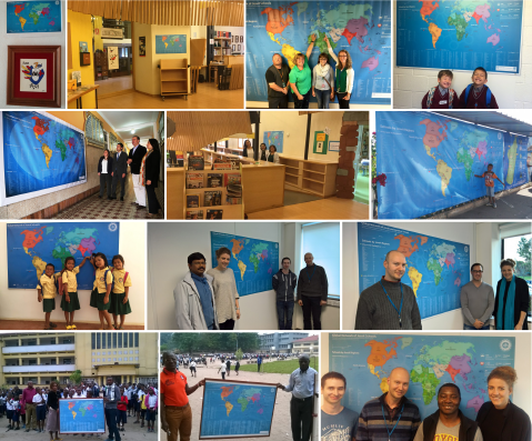
Locate and learn more about the worldwide Jesuit schools online. The Educate Magis Online Map is available in interactive form and can be applied to your website.
Go to the interactive map
The Interactive or Online Map of the Jesuit Global Network of Schools is available to be embedded in a website, using the Educate Magis Map
iFrame.
Please use the following code:
<iframe src="https://www.educatemagis.org/schoolmap/?latitude=48.35&longitude=16.45&default-zoom=2.6&min-zoom=2.6&max-zoom=18" width="100%" height="400px" frameborder="0" align="center"></iframe>
Note: You might want to ask your webmaster or web developer to do this for you.
- You can change the width and height of the map using the Width and Height paramaters in the iframe tag
- You can set the zoom level of the map by passing a default-zoom paramater in the iframe url
- You can also change the center point of the map by passing in the latitude and longitude paramaters to the iframe url
If you need any assistance with this, please email us at maps@educatemagis.org